2009 – NSSL Internship
In the summer of 2009, I interned at the National Severe Storms Laboratory in Norman, OK. It was a great experience to meet and work with severe storm researchers and operational forecasters. Oh, and I got to take days off and go chase, of course!
May 02, 2009 – You have entered The Suck Zone
Hey everyone. I didn’t want to start studying for final exams just yet, so instead I made this weblog to keep track of my trip out west this summer.
My internship at the NSSL begins on May 26. If the weather works out, I’ll be taking a few extra days to travel and chase down some storms beforehand. Right now, I’m estimating my departure will be around May 19.
I set up a Twitter account named suckzone for rapid-fire updates from the field, so you can more easily follow without a lot of tweets dilluting your feed.
Also, I may migrate all the old “Storm Chasing for Dummies” posts here.
May 06, 2009 – Chaser tools: the start page
When you’re out in the field chasing, getting and analyzing atmospheric data can be a crucial part of the day’s success. Many chasers have a special Web page where they link to commonly-used online weather maps and data sources. The pages are typically simple and text-based so they load quickly over a slow, spotty Internet connection.
I’ve populated my own start page with my favorite data sources in a variety of different data types.
The page’s design fulfills a few design requirements:
- The entire layout fits on the display of my laptop (1024 × 600)
- The links are large, so that they are easy to see and click
- The links cover broad range of both time (daily trends and real-time) and location (local, regional, and national)
Firefox and Safari users will see nice, rounded edges on those links.
The current time is displayed in UTC, because all the weather maps are based in this time zone and I never have any freakin’ clue how to convert it, especially when I’m dancing between Central and Mountain time. It’s crucial that the computer’s clock and time zone are set properly, however, because the calculation is based off the system clock.
I’ll probably tweak this over time as I find that it meets certain needs and fails to meet others.
Bonus feature: I just found the old start page from when Jake and I went storm chasing in 2007. I thought, when making this latest page, that I was being clever with the categorization of data into “today” and “now”. I guess I was just copying myself.
May 12, 2009 – Take my card
The past few days have been a little hectic as I simultaneously unpack from a year at college and re-pack for a summer out West. Preparation for storm chasing is also in progress. The next post will be all about all the different tools I’ll be using.
In the mean time, I will share a little gem I found when I was scouring my room for my window-mount tripod.
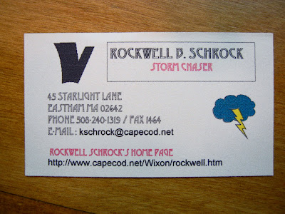
Classic. The movie Twister was released May 10, 1996, right around the time this card was made. This is no coincidence, I assure you. Yes, that is a large, bolded “V” character in the top-left. I thought it looked sort of like a tornado.
So the year was 1996. See that URL on the card? It’s from Cape Internet, who provided dial-up access to home subscribers, where “56K” meant “28.8K on a good day”. To get the whole picture, you have to see the site in all its archived glory.
Check out that awesome animated GIF header with dark, rolling clouds and a big lightning bolt. This page has everything: rainbow rulers, pictures of my house, my pinewood derby car and my virtual pet from the game Dogz. It has a hit counter (now defunct) and a personal interest survey. Make sure you visit the old Garfield page, as well.
Whew, what a blast from the past.
May 14, 2009 – Video: Storm chasing high technology
I was going to write a long and detailed post about the multitude of technology that populates my chase vehicle. Instead, this brief video will have to temporarily suffice.
There are also some pictures of the equipment.
May 15, 2009 – Outbound Plan A
View Storm Chasing 2009 – Outbound Plan A in a larger map
The laundry is done. The AC adapters are stowed. The Matrix is packed. All systems are go.
Well, except for the weather systems.
The original plan
I’ve given myself a few extra days to reach my destination of Norman, Oklahoma, so that I can take some time to chase storms. Of course, I was assuming there would be storms during this time, which is usually peak storm season.
That is where the Plan A begins to fall flat.
Forecast discussion
I’ve been looking at weather models for the past few days. They can only predict up to 8-10 days in the future, and that far in advance they are relatively inaccurate. So, when I started looking at the maps a few days ago, I was praying they were wrong. However, as we get closer to the target date, not much has changed.
The models show a cold front sweeping across the nation over the next few days and scouring out the warm temperatures and moisture necessary for the formation of storms. Sometimes in this scenario, winds immediately shift back to the south and moisture quickly returns from the Gulf of Mexico, but a low pressure system centered over the Gulf is blocking this from happening. The result is a “death ridge” that results in hopelessly clear skies.
Some moisture appears to creep back into the Plains late in the forecast period, though the models differ on the timing and intensity of this event.
Outbound Plan A
This much is certain: I will be spending Saturday and Sunday in Connecticut visiting with friends and family, and will begin traveling west on Monday, May 18.
I plan to target Lincoln, Nebraska for Thursday. Local forecasts in Lincoln show a chance of thunderstorms on Thursday, coincident with the slight moisture return mentioned above.
This target also places me in a good position to travel north or south as necessary to chase for a day or two. Then it’s another full day’s travel due south, from Lincoln to Norman, on Sunday.
Do a rain dance for me.
P. S. You may be wondering what the deal is with that deviation in my route through Pennsylvania. Well you couldn’t pay me to take Interstate 80 through Pennsylvania. No way. I hate it. It’s only an extra hour to go this alternate route, and it will be worth it.
May 18, 2009 – Outbound leg 1
- Route map
- Trip meter: 646 miles (646 miles total)
- Time: About 12 hours
- From: Portland, CT to Zanesville, OH
- States: Connecticut, New York, Pennsylvania, West Virginia, Ohio
- Summary: Expected driving distance was greatly exceeded! Driving conditions were perfect; roads and traffic were great; Comfort Inn rocks
- Weirdest town names: Eighty Four, California, Lover
Whew! What a great day. There’s not much to say beyond the basic summary above. I avoided I-80 like the plague, and I’m so glad I did. Driving conditions were fantastic on all fronts. The weather was initially cool and cloudy, but the clouds dispersed and it warmed up. There was no traffic congestion to speak of, though the two-lane sections of I-84 and I-91 were a little hairy at times.
It also helps that once you get out of New England, people stop driving like idiots and exhibit a little thing called courtesy.
Even with a carload of GPS technology, I still managed to get a little lost. I was distracted by some construction and got on the Pennsylvania Turnpike, I-76, going east. Normally this isn’t a problem, but the Turnpike is a toll road and the next exit wasn’t for ten miles. I did end up getting lunch before I turned around, so I guess it all worked out.
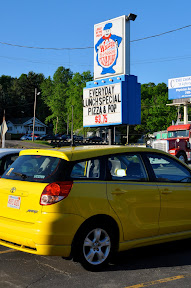
I had dinner in Cambridge, OH at Wally’s Pizza. It was a tiny brick building with a ten-space parking lot and a cute little sign. The pizza was fresh and it really hit the spot. Two thumbs up.
Tonight I’m holing up at the Comfort Inn in Zainesville, OH. When we chased in 2007, staying at a Comfort Inn was always a pleasant surprise and a great deal. I’m glad to report that nothing has changed.
Tomorrow might be the last driving-only day. I hope to end up in Iowa. I could end up tracking down some storms on Wednesday! I heard that VORTEX2 trekked north to Nebraska today. I bet they are targeting the same area as me. I’ll have more in-depth weather discussion tomorrow.
May 19, 2009 – Outbound leg 2
- Route map
- Trip meter: 684 miles (1330 miles total)
- Time: About 11 hours
- From: Zanesville, OH to Newton, IA
- States: Ohio, Indiana, Illinois, Iowa
- Summary: Another flawless drive
- Weirdest town names: What Cheer, Normal
Today was more of the same, except I didn’t get lost this time. The weather was perfect for driving, traffic was minimal, and there was a lot of construction but nearly no slowdowns.
Forecast discussion
Tomorrow, a weak low pressure forms in the ND/SD area as a cold front dives southeast across SD and NE. There will be some moisture in this area. Combined with the cold front, there becomes a chance of isolated, high-based, moisture-starved supercells.
The winds look good at all levels. There is instability and lift present along the cold front. Assuming I can get there in time, and I get the right location, I think tomorrow might yield some fun, easy-to-chase storms, once I track them down.
Target area
I think I need to get further north, no matter what. Also west. So, northwest. I will take I-80 west and then I-29 north to Sioux City, at which point I will deviate from the interstate for the first time this trip and take Route 20 west to Valentine, NE. If the cold front has not yet met up with me by this point, then I will sit in Valentine and take it from there.
It will take about 6–7 hours to get to Valentine. If I leave around 8 AM, this places me in Valentine around 3 PM. I hope this is enough time.
Follow along on the live map and on Twitter.
And wish me luck!
May 20, 2009 – Nebraska Route 2 chase
Video
Write-up
- Route map
- Trip meter: 703 miles (2033 miles total)
- Time: About 14 hours
- From: Newton, IA to North Platte, NE
- States: Iowa, Nebraska
- Summary: Perfect day! I chased the best cell of the day and had a great time tracking it down and meeting other chasers.
AHHHH what an amazing day. Where to begin?
I left Newton, IA at 8 AM sharp and cruised westward on I-80. Based on the SPC outlook and the locations of other chasers, I decided to skip going north in I-29 and instead took I-80 all the way across Nebraska.
Iowa had strong, gusty, southerly winds that made driving difficult, but the winds decreased as I made it further into NE. The sky was mostly cirrus and cirrostratus – nothing too promising! I drove and drove and drove and finally some cumulus bumps appeared on the horizon, in a line. I ended up driving through this line, which would later become a linear multicell system that I would not chase. This turned out to be the right choice, though I doubted myself at first.
I made it into North Platte around 2:15 CDT. I could go north, directly towards the cold front, or continue west towards the area of better moisture convergence. Some storms had already formed in eastern Wyoming and northeastern Colorado, and everyone else was out west, so I followed.
An hour later I cruised into Ogallala, gassed up, and booked it northward on Route 61. Into the sandhills I went. I stopped a few times to observe the new, small storms approaching to my northwest. I met up with some other chasers who were watching and waiting for the storm that I would eventually end up chasing all day.
We were just south of Hyannis. As the storm approached, I could begin to make out its solid, smooth updraft base. The precipitation was separated off to the north. GRLevel3 showed some weak to moderate rotation. I went north of Hyannis on 61, hoping to run into the VORTEX2 crew. A local told me they were in the town earlier, so I must have missed them.
I wanted to continue north, again towards the cold front, but then I thought about it and that didn’t make any sense. I had a storm right here, in front of me. I’d just stay in front of it and see how it went.
Well, how it went! I went east on Route 2, staying in front of the storm as I would stop, snap some shots and video, then hop in the car and cruise ahead. Chaser convergences were common along this road as we all were treated to the “cell of the day”.
I ducked back south on Route 83 to try to skirt in front of the storm to get some pics. Unfortunately, I cut it too close! As I watched the clouds engulf the sky above me, the precipitation shafts swept across the road and the car was pelted with gusts of wind, heavy rain, and, briefly, some hail.
Relatively unscathed, I sat south of the storm, but the view wasn’t that great because of all the precipitation. I watched the lightning for a bit and ate the second half of my Subway sandwich, then travelled into North Platte for the night.
North Platte, of all places!
I am beat! I don’t see anything interesting for tomorrow. Maybe I’ll sleep in and take it slow.
May 22, 2009 – Off the Beaten Path: Nebraska sandhills and Kansas Cosmosphere
- Trip meter: 548 miles (2581 miles total)
- Time: Two days
- From: North Platte, NE to Hutchinson, KS
- States: Nebraska, Kansas
- Summary: The Kansas Cosmosphere is amazing.
I took the last two days off from chasing because there wasn’t significant severe weather potential, though there were some storms today in the same region they were on Wednesday, in western Nebraska. Just my luck. It’s okay, though. It would have been a pain to drive so far to Norman after that, and I wouldn’t have gotten to do a little exploring.
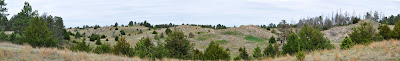
Nebraska National Forest
Thursday I drove up to the Nebraska National Forest and hiked around for a bit. The forest bills itself as the largest hand-planted forest in the world. It’s situated right in the middle of the sandhills, so I guess it would have to be! The weather was a cloudy and windy, but warm, and it was nice to get outside and hike around a bit after three straight days of driving.
I have put up a small photo gallery.
 |
| From OBP – Sandhills |
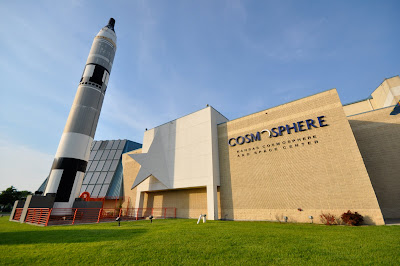
Kansas Cosmosphere and Space Center
When I got back last night I scouted out things to do today. I checked the Kansas tourism website and settled on the Kansas Cosmosphere and Space Center in Hutchinson. It sounded kind of cool, and it was on the way to Norman, anyway.
Wow! What a treat! The Cosmosphere is a museum that specializes in space artifacts. The Hall of Space walks you through the entire development of space travel: from the first experiments and the German V2 rockets, through the Cold War, and up to the Apollo missions. The artifacts they had there were amazing: an SR-71 Blackbird, recovered Mercury and Apollo capsules (including the Liberty Bell 7, which was only recovered from the ocean in 1999), the USSR’s backup Sputnik, a complete set of German V-1 and V-2 rockets, and so much more. Here is a list of artifacts on display.
 |
| From OBP – Cosmosphere |
Be sure to see the full photo gallery.
This museum is a gem in the middle of nowhere. I went on a Friday evening and it was empty. Completely empty. For anyone with even a passing interest in aeronautics or space exploration, I can’t recommend it enough.
I have a really fun stop planned for tomorrow. You’ll never guess what it is. Never, ever, ever!
May 23, 2009 – Off the Beaten Path: The Twister Movie Musem
- Trip meter: 269 miles (2850 miles total)
- Time: About 6 hours
- From: Hutchinson, KS to Norman, OK
- States: Kansas, Oklahoma
- Summary: Visited the Twister movie museum, and moved in to my apartment in Norman.
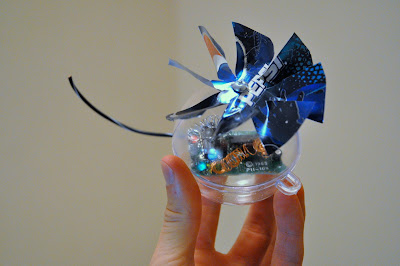
Today I took my time traveling from Hutchinson to Norman. I went a little out of the way to stop by the Twister Movie Museum in Wakita, OK (note: the movie version of Wakita is in Kansas).
I figured this was a storm chaser Mecca, of sorts; I turned out to be right. VORTEX2 had been there a few weeks ago, and Cloud 9 tours was there this week. A lot of international visitors come here, as well.
The museum is in downtown Wakita. For the movie, the entire downtown was turned into a disaster scene. They tore down many buildings and made main street ground zero. The museum had lots of photos of the entire process. The curator there told me that Bill Paxton was a really nice guy and would often hang out and play football with the locals, but Helen Hunt “was the complete opposite […] she didn’t make many friends here.”
They also had the Dorothy prop that fell off the truck in the movie, along with lots of signed goods, and even a Twister pinball machine donated to the museum from Bill Paxton (“He didn’t want it”).
The pictures aren’t that great, but I do have one thing to remember this by… a replica Dorothy probe ornament, complete with Pepsi can windmill, made by the curator lady herself:
 |
| From OBP – Twister Movie Museum |
I continued on to Norman after that, and moved into my apartment on campus. This evening there was a severe thunderstorm warning in downtown Oklahoma City, just twenty miles away! If it weren’t in a metropolitan area, I definitely would have chased after it.
I hope this is a good omen.
May 31, 2009 – Beginning the internship
The first week of my internship is complete! At lot has happened since I arrived a week ago. I’m settled into my apartment and am getting to know my roommates. I know where the closest Wal-Mart is, and I’m already starting to know my way around Norman. Today I took my longboard for a ride around campus to get to know it a little better. It’s 93 degrees here, but it’s a dry heat! I barely even broke a sweat because the relative humidity is only 21%.
The NCAA Division I Norman Regional baseball tournament is occurring at the baseball field outside my window right now. As I’m writing this, OU just hit a grand slam and the crowd went wild. They lost last night, so things are looking up for them now.
We’re living in the apartments with many students who are also visiting from across the country. The REU program has a weather research program at the National Weather Center, as well, and everyone here gets along great. There are even students here on a golf management internship.
The workplace
Working at the NWC is a real treat. I’m quickly learning exactly how small the field of meteorology really is. For a scientific field with such a strong focus in both research and real-world operations, it’s always surprising how tightly-kniw it is. You do something great, and the whole world knows about it. You goof, and you never hear the end of it. Someone told me about Hollings students who went chasing last year, and their car broke down near the path of a tornado. The heckling went on for weeks.
Of course, this makes it trivial to form professional connections. There are probably no more than two or three degrees of separation between any two people in the field, especially when so many are under the same roof. Opportunities open up simply by talking to the right people. I guess this is how it works in the real world.
It’s really neat when you have seen someone’s name plastered on weather forecasts, academic papers, and on television, and then one day you happen to walk by their office.
The project
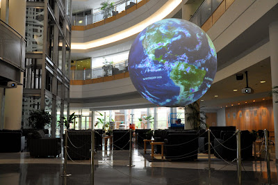
My project is coming along slowly, but surely. I’ve been playing a lot with the Sphere, trying to get a feeling for how to best utilize it. It’s also tricky to get videos and images in the proper format for displaying, and this is a major hurdle that I think I’ve figured out.
Once I get some more content, I’ll be able to post some pictures as the project progresses.
The weather
The weather here has been hot. And sunny. And dry. Meh.
Hopefully that will change come Tuesday. As some better moisture makes its way back into the region, we have the potential for some good storms. We’re in a “slight risk” area for Tuesday, so my fingers are crossed.
June 05, 2009 – Wrecked
Summary
- Route map (outgoing only)
- Photo gallery
- Trip meter: about 750 miles each way
- Time: 12+ hours each way
- From: Norman, OK, to Lisco, NE, and back
- States: Oklahoma, Kansas, Colorado, Nebraska
- Summary: Things were looking up. Then down. Then up. Yes, I rolled the car over in the middle of nowhere
The set-up
Upslope flow! Good low-level shear! Sufficient moisture! Decent upper-level winds! The Storm Prediction Center promised all this, and more! There was a nice 10% tornado area in the WY/NE/CO/KS corner area.
VORTEX2 nailed it and scored big today in Wyoming. Even though we left at 7 AM, we could not get to this storm in time.
This was intended to be a multi-day chase. We were to chase in the western Nebraska area today, then go due east on I-80 for another chase day in the eastern part of the state, and then probably make an easy drive back to Norman on Saturday night or Sunday.
The chase
I chased on this Friday with Travis and Astrid. We left Norman at 7 AM, targeting Goodland, KS. This would put us on the edge of the high-tornado-risk area, and we could decide where to go from there. The drive was long, but Travis and Astrid made great company, and it was fun seeing the sights and talking.
Along the way, I broadcast on the amateur radio national calling frequency, 146.52 MHz. I knew there were other chasers in the area, so I thought I might get in touch with one. The one chaser who responded? Kevin Manross, who was chasing with Doug Crauder and John (see Ponca City Bust). They were a few miles behind us on I-70.
They were headed towards the Wyoming storms, which were ongoing at this point. We decided to follow them. Kevin is an experienced chaser, and he was glad to have us along. At one turn, we hesitated and hung back a little, waiting for things to develop closer to our position. I think this was in NE Colorado. They went on ahead, so we didn’t see them the rest of the trip.
The Wyoming storms were moving into western Nebraska, and they were looking better and better. We decided to follow suit and go further north.
As we got closer and were on I-80 west towards Sidney, a big tower popped up to our southeast. It formed explosively with a nice pileus cap, and a tilted-over appearance. In fact, it was too tilted over. By the time we had turned around and gotten back in front of it, you could see that it had stopped ingesting good air and it was simply hanging there, not doing much. The top of the tower was directly above us, and we were many miles away from its base. The whole structure was really funky.
By now, the ongoing storms were pretty close, and we couldn’t backtrack to the west, towards them, because then we would not have time to cut in front of them and get into a decent position. We had to go due north to cut them off.
I think we went north near Lodgepole, NE. All the roads in this area are one-square-mile-grid dirt roads. They were dry and in good condition, as dirt and gravel roads go, so we made the most of it. We were headed towards route 26, a paved highway that runs NW/SE, and would have put us in prime position to stay in front of these cells to our E/NE for the remainder of daylight.
The accident
Astrid was driving, but she got too excited with the storm getting so close, so we pulled over and I took the wheel again. We were about three miles south of Lisco, NE when the accident happened. The road crested a hill that sloped down into the North Platte River valley. I tapped the brakes at the top of the hill, because I could not see what was coming up over the hill. The tires skidded on the loose road surface and the car swerved to the right a little. I corrected back to the left and the car went into the wide left-hand ditch. I think I corrected the wheel back to the right and that’s when the nose of the car dug into the soft earth and rolled over. It all seemed to happen in slow motion, and I couldn’t believe it was happening as the ground filled the windshield. It was surprisingly soft and not jerky at all. The car landed on its wheels. We’re still not sure if the car rolled completely, because of the sporadic damage, but it sure felt it. There was a lot of flattened grass as well, and many loose items in the car had definitely made it to the roof and back.
We were all wearing our seat belts, and everybody was perfectly fine. Astrid had been beaten up by her huge purse with her laptop in it, and I had some small cuts on my arm from broken glass, but miraculously we all walked away. We surveyed the damage. My subwoofer in the trunk had come loose and broken the right-rear window. The whole driver’s side of the car was crunched in. Luckily, the driver’s window had been left behind in the road, because I had to climb out the window of the door, which wouldn’t open. Three tires were blown out. The front and hood were all crushed in, but there was little damage anywhere else. Also my magnetic-mount ham radio antenna had come off the roof, so it must have struck the ground.
The rescue
Well. Nobody was hurt, and no property was damaged but my own, so we didn’t need to call an emergency rescue. Who’s the next logical person to call? At the time, it seemed obvious: AAA! I spent a long time on the phone with them getting a wrecker to come get us. It was 60 miles away, in Sidney, NE, so we would have to wait. We also got back in touch with Doug and gave him our coordinates so he could come pick us up. No problem.
I’m kidding, of course. The storm, originally passing to our north, turned right a little and began to track directly over us. It has a severe thunderstorm warning, and it was a beautiful mothership supercell. At the last moment, chaser Cory Schuler passed by just as the storm was about to eat us alive. We piled into the back of his Subaru and he took us north to Lisco. We took shelter in the local fine dining establishment, The Roost, just before the storm hit. The rain was heavy and there was some pea-size hail. Then the storm got a tornado warning on it, and GRLevel3 confirmed a broad but well-defined couplet. That storm was trying to produce! If it had, we would not have been able to see or hear anything because of the heavy rain. We would have been toast – Nebraskan toast, with gravy on top.
Well the storm passed and didn’t produce a tornado. The wrecker showed up, unable to traverse the mud-slicked roads. Some kind locals took us back to the car in their Dodge Ram, and despite the four-wheel-drive, the truck slid all over the muddy road. A state trooper had somehow arrived to the scene, and he gave me an accident report to mail in. I grabbed my things and then the wrecker guy took us back to Sidney.
Doug and Kevin would have come to get us, but they were far away, getting into position for the next day’s chase. We were going to meet up with them the next day if necessary.
Getting home
Seven hundred miles. Car-less. No rental cars within fifty miles. It was a Saturday, so most rental places are only open a few hours in the morning, so we would only have one shot to get a car. It was a bleak prospect. Madison Burnett, a fellow Hollings student, had also chased with some friends and spent the night in Ogallala, about an hour east. She came out of her way to pick up Travis and Astrid. They drove another hour to Sterling, CO, where we could get a rental car home, as Madison had no room for three of us in her car. When they got to Sterling, they were told that there were no rentals available. Astrid explained our situation and they were magically able to find something for us. Whew. Astrid and Travis picked me up in Sidney and we uneventfully booked it back to Norman.
So ends that adventure. The Matrix was a great car and it treated me well. We will all miss its distinctive yellow color and its ability to stand out in the masses of dreary cars. RIP Matrix.
A statement to the storm chasing community
I understand the word of my accident has spread throughout the chasing community. In fact, my NOAA mentors learned of the accident through VORTEX2 before I had the chance to tell them myself.
I do not chase recklessly, and I do not wish it to be thought that this is the case. I always emphasize safety when I chase, and I always bring this up when I tell others about how I chase. I am humbled by my accident, and I hope it does not reflect poorly on the chase community by portraying them as daredevil thrill-seekers. That’s not what chasing is about.
I hope that other chasers may learn from my mistakes. Take it slowly on both unkempt back roads and paved ones. Have a solid backup plan if things go horribly wrong. Never, ever take these storms for granted – they will mess you up. Luckily this storm didn’t, but this story could have ended any number of grim ways.
June 09, 2009 – Ponca City bust
Summary
- Route map
- Trip meter: about 350 miles
- Time: 10 hours
- From: Norman, OK, to Winfield, KS, to Ponca City, OK, back to Norman
- States: Oklahoma, Kansas
- Summary: The moderate risk for southeastern Kansas never panned out! The shear was not at all what was expected. Intercepted some small cells near Ponca City, but it quickly became an MCS.
The set-up
Today was the day. A moderate risk in early June is no joke, and we took this one seriously. Too seriously.
The conditions were relatively good: high dewpoints, high temps with decent surface heating throughout the day, sufficient mid-level jet, and some shear. There was also a nice boundary set up by an MCS churning through west-central KS and into MO that morning.
I hate to ruin the ending, but the 850mb winds veered sharply as the day went on. The surface winds were already out of the southwest, so this removed nearly all the low-level shear. Poor storm organization led storms to quickly evolve into the multicellular mode.
The chase
We left Norman around 1 PM, cruising north on I-35 with Wichita as our target. There was a bulls-eye of good instability and shear that had Wichita at its center. A tornado watch soon went out.
I went with Doug Crauder, Derek, and John Lloyd. We met up with Doug’s parents along I-35 near Stillwater, OK and swapped cars. The six of us piled into their minivan and continued on northward.
But, wait! That MCS boundary, parallel with the KS/OK border, didn’t stall north of Wichita as expected. It continued to truck southward and soil the air behind it. We got off the interstate far south of Wichita and decided to go eastward. Though we heard that V2 was far to our west, we thought there were better conditions to the east, and development in the sky just looked better that way.
We sat north of Winfield, KS for an hour or so, just waiting patiently and watching. There were several other chasers and spotters out and about. We were waiting for something to develop, and we watched tower after cumulus tower explode upward. It was really fantastic to watch everything come together in the atmosphere. However, nothing was able to get going, so we ducked back south along Route 77 back into OK. We cut off a small, ongoing storm that was heading east across our path. We got some rain and a few seconds of pea-size hail.
We then went west from Ponca City, OK and got trapped between this cell and another one to its southwest. We danced around and did a good job avoiding and major precipitation cores from these storms. It was fun and a little hairy at times because we were trying to avoid some major greenage (monster hail) in the storms, though we were never really in danger. The crosswinds were really strong, but we eventually turned back south on Route 156 and escaped.
The southern storm initially looked really nice. It had a nice clear updraft that may have been broadly rotating. As it passed over us we again went south and stopped to watch, but by now it had simply dissipated into nothingness. This was along Route 156, SW of Ponca City, in Noble County.
Meh. It was getting dark, and nothing else showed any sign of further development. We took Route 177 back to Doug’s house for a bit, had a brief tour of the OSU campus (it’s nice!), then went back to the Stillwater exit in I-35 and swapped the cars again. We got back to Norman around 11 PM.
Acknowledgements
Thanks to Doug’s parents for letting us use the minivan! I hope they had a fun trip, and that we didn’t alienate them too much with our vernacular and TLAs (three letter acronyms).
Also, I had fun chasing with a whole team of people. It’s great to divvy up the workload between driving, navigating, looking at data, and listening to the radio. We also were able to reach unanimous decisions pretty easily. Overall we made a good team. I hope I get to chase with these guys again.
June 12, 2009 – Norman Tornado
Summary
- Trip meter: about 100 feet
- Time: about an hour
- From: our apartment to the next apartment over
- States: Oklahoma
- Summary: This one caught us off-guard
The set-up
This was a typical stormy evening in central Oklahoma. As the afternoon wore on, towering cumulus filled the sky as surface temperatures reached 90 degrees. As the sun set, the sky was lit up by lightning of storms all around us. We stood in the breezeway of the apartments, shooting the breeze (pardon the pun) and watching the show.
It was around 10 PM that things got interesting in a hurry.
The chase
The storm began innocently enough a few miles northeast of our apartments, in our very own Cleveland County. It popped up quickly, and it didn’t look too strong because it was so close to the KTLX radar, and the radar beam shot way under the base of the storm.
The thing is, the storm almost appeared with a hook already in place! Twenty minutes after appearing as a random blip, it had a small, strong couplet and a nearly circular hook. It produced the brief EF-1 tornado around this time, and ten minutes later the circulation dissipated.
Several minutes after this, the tornado sirens were sounded across Norman. They went off briefly, then came on again. The tornado had already happened! I heard later the local emergency manager had technical problems sounding the siren remotely, hence the delay.
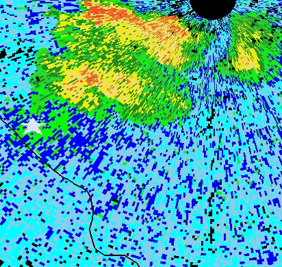
In this animation, which spans 10:04 PM to 10:36 PM, the white star approximately denotes our location. Look at that hook! Awesome!
Our reaction
This all happened so quickly we didn’t have time to get in any sort of position to see the tornado. The entire time this happened, not a cloud passed over our heads; only the stars were above. It was very surreal. There were many trees around so we couldn’t see the base of the storm.
Doug drove up to the National Weather Center to go up to the observation deck, but by the time he had made it there, others already there told him they had seen the tornado and it had dissipated.
When the sirens sounded, some folks in the neighboring apartment bolted for their cars. They were going to find shelter somewhere else, they said in the university library. I don’t know what they were thinking – it’s very dangerous to be in a car when a tornado is near, especially at night when you have no idea where you are going or where the storm is. We talked them into staying, and they took shelter in our apartment, since it is on the first floor and is the safest. Meanwhile, all us weather nerds are standing around outside with cameras, laptops, and radios, staring skyward. Go figure.
This was the closest I’ve been to a tornado so far, estimated at about five miles. I didn’t even have to drive anywhere. But I didn’t get to see it. No photographs, no video – nothing but a shaky video of us running around the apartments. Oh well. There’s always the next chase, next spring. It will always be there.
Here is a great video and a nice frame grab from other sources.
June 13, 2009 – Turkey Day
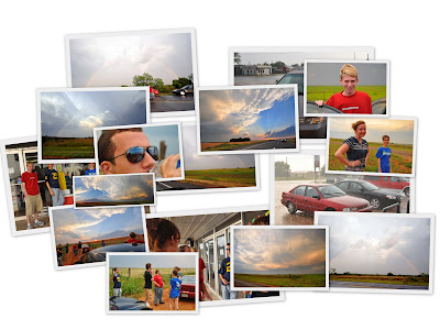
Summary
- Route map
- Photo gallery
- Trip meter: about 550 miles
- Time: 11 hours
- From: Norman, OK, to Turkey, TX, and back to Norman
- States: Oklahoma, Texas
- Summary: This was my first Texas chase! Though we were all turkeys today in Turkey, TX.
The set-up
Today was a moderate risk. I didn’t really have time to analyze why, because I got up at 1 PM and basically headed straight out the door. There was supposed to be some action with a strengthening low-level jet, along with temps near 100 and high dewpoints to match. The cap was strong, but with strong surface heating it was to give way later in the afternoon into evening.
Our trip with two people in one car quickly morphed into a seven-person, two-car trip.
Misery loves company!
The chase
South, or west? That’s always the big question when we’re headed out of Norman towards the dryline. Today, we decided west. Then south. Then west again.
We started out west on I-40, but thought that warmer, more sheared air would be to the south, below the warm front. The front was clearly visible cutting east/west directly through the Frederick, OK radar that morning. Or maybe it was the Enid radar. Not sure.
We drove south on route 183, initially trying to get in front of a monster, tornado-warned cell that looked great on radar. It was just too far away, though. By approaching it from the north, we would have had to core-punch through the storm’s precipitation core, which almost certainly included severe hail. Too little, too late.
So we went west on route 62, toward the dryline. We targeted a developing cell near Turkey, TX that had some decent rotation and nice structure. We couldn’t see much out our windows because the anvil blow-off from the previously-mentioned storm was blocking out the light to everything below. It was all just a big, hazy, socked-in mess.
The storm was roughly east of Turkey. It was trekking ENE but then turned right and tracked more ESE, crossing our path. It was a race to the finish as we drove SW on 86, trying to get to Turkey to cut in front of the storm and get on its south side. We saw on the computer that there were many other chasers already on this storm, and Cloud 9 Tours reported a brief rope tornado with this cell.
Well, as our luck would have it, the storm petered out and we were left in Turkey with pouring rain and crushed dreams. We didn’t get to see much of anything.
But things get a little better
At the Turkey gas station, we stood outside and discussed our next move. Then, out of the minivan parked two cars down, my NOAA mentor Daphne Thompson emerges! She was chasing with her husband Rich, a Storm Prediction Center (SPC) forecaster, and her sons. She knows everyone who was there because she helps run the Hollings program here in Norman. They had beat us to the storm, but had only seen a wall cloud, nothing more.
And you know what? They had driven from Norman, too. They have years and years of storm chasing experience and real-world operational forecasting. And we were in the same town at the same time.
I don’t care that we busted this chase. We still must have done something right.
Then the fun begins
On our drive back, the sky was perfectly clear to the northwest, where the sun was setting, and the remains of our storm tracked along to the southeast. The result was a brilliant, full rainbow that we got to watch for a half hour as we drove back on 86.
We stopped to take some pictures of the rainbow. When we climbed back into the car, the song I Can See Clearly Now was playing on the radio. The lyrics? “Here is the rainbow I’ve been waiting for / It’s gonna’ be a bright, bright, bright sun-shiny day.” How perfect is that?
Anyway, we then caught up with some other cell along 62, west of Altus. It was running south of us, parallel to the road at a high speed, so we could have been it for a long time. It initially had a high VIL reading, which means it probably produced some larger hail, but this one did not last long and we only experienced some rain and gusty winds as we poked through it. It was darker now, and the lightning was continuous and all around us. It really was a sight.
We stopped at Mickey D’s in Altus, OK for some fine dining, then went straight back to Norman. We got back around 1 AM.
Tired.
Frustrated.
But still feeling that today wasn’t as bad as it seemed.
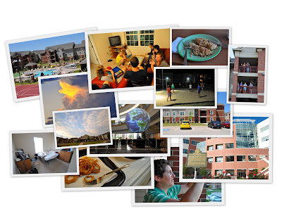
August 13, 2009 – Home again
Housekeeping
I just finished and posted an old chase summary from June 5, the day I totaled my car. It’s a long entry, as you might expect.
I also wrote an entry for the infamous June 12 Norman tornado.
My project
My summer project was a huge success and it came out really well. The final product was an eight-minute presentation for Science on a Sphere, titled Cooking Up A Storm. It walks the audience through the atmospheric setup for a typical severe weather day.
I showed it to a few tour groups and to my peers, and it was received very well.
You can view a rendering of the video or how it appears on the sphere. There is more information and a download on the SOS site.
End of the internship
After all the excitement of chase season, my internship ended uneventfully enough. I spent a lot of time with my newfound friends. To begin a typical evening, we would all come back to the apartments and fix ourselves dinner. Then we would get together at dusk and play volleyball or basketball until we were exhausted. Then we’d take showers and all get together to watch DVDs of The Office. It was a fun routine.
We did a lot of fun things on weekends too. We went to Oklahoma City for the Fourth of July weekend to go to White Water Bay and see fireworks. We played laser tag at HeyDay, and went to see the Oklahoma City RedHawks, a minor-league baseball team. There was also the midnight showing of Harry Potter and the Half-Blood Prince. Oh yeah, and my mom visited as well and brought me a car so I could drive home. I love you, Mom.
Silver Spring
The final week of my internship was spent at NOAA headquarters in Silver Spring, MD. I drove there in three days, simultaneously enjoying the beautiful scenery of the southeast and cursing Tennessee drivers.
Presentation week went really well. The presentations dragged on and on, but that was expected. I met up with a lot of people I’d met during orientation week a year and a half earlier. We went into D.C. twice to sightsee and to nosh on some Legal Sea Food.
Thanks
Where to begin? Thank you first to Daphne Thompson for being a great first-time mentor and for lending her melodious voice for the narration of my SOS video. Thank you also to Keli Tarp for organizing the Hollings program in Norman for all eight of us; she did a bang-up job. Thank you also to the folks from the NSSL IT department, especially James Murnan for helping me with the video production and sound effect stuff. Finally, thank you to NOAA’s Ernest F. Hollings scholarship program and all its organizers, like Pai Moua and Chantell Haskins. This was a great opportunity and learning experience.
I wish the best of luck to all my friends and peers! In no particular order: Darren, T-mas, Justin, Stephanie, Madison, Liz, Kristen, Hannah, Lauren, Travis, Astrid, Doug, Jeff, Preson, Alex, Jonathan, Lindsey – you are all great.
I wouldn’t trade this summer for any other.
Where to go from here?
Senior year begins in two weeks, and I will have to get back into that routine again. I may post some more pictures or videos as I go through and process them. Hopefully some tropical storms spin our way so I will be able to blog about that! Then comes the fun winter weather and the infamous Storrs Wind Vortex To Hell. In the meantime, the blog will only be updated intermittently.
Thank you for reading!