2006 – Silver Lining Tours
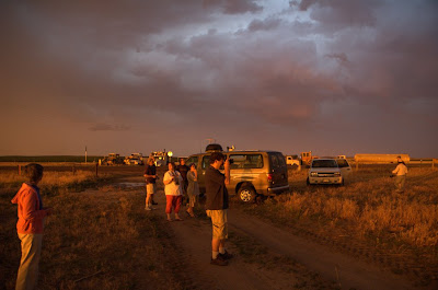
In 2006 I chased on the Plains from June 18–23. I travelled with Roger Hill and the Silver Lining Tours crew. We spend most of the time in central and northern Nebraska, but also ended up in Kansas and northeastern Colorado.
Despite a frustrating season for all chasers, Roger gave us a great show. A lack of sufficient moisture was the main obstacle to mesoscale development during this week.
June 16, 2006 – Chasing next week!
Finally! The time has come! I leave for chasing with Silver Lining Tours tomorrow. We will be chasing from Sunday through to next Friday. Hopefully this nuclear ridge that has held in place for the past month will move on and hopefully the mid-level winds and moisture levels pick up by the end of the week.
I will be posting to this blog very often. In addition to regular posts and pictures when I find Internet access, I will also be recording voice messages while we’re on the road, so check the blog often during the upcoming week.
June 17, 2006 – Trains, Planes, and Automobiles
Just checking in from Logan! I’m here excessively early, as always, with over an hour to kill. I’m taking United flight 267 at 11:20. Everything is going smoothly so far. My carry-on bag was screened at the security check-in, probably due to the excessive electronic gear inside (laptop, camera, iPod, Nintendo DS Lite, etc.).
Okay, enough with the boring details. More posts to come.
Update after meeting up with the tour group and having dinner:
June 18, 2006 – Day 1 Summary
Summary
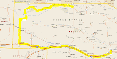
- Route map
- Photo Gallery
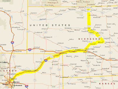
- Trip meter: 441 miles
- From: Denver, CO to Valentine, NE
- Summary: No severe storms :(
Long summary
Before this morning, today’s outlook for severe weather was less than ideal. We were originally intending today to be a relaxed travel day to get into position for tomorrow, but the situation had changed by morning. The SPC issued a slight risk area for central NE, which Roger agreed with and we subsequently went after. Dewpoints were great in the high 50s, but other factors did not fall into play.
Radar showed a great boundary which formed a cumulus field early in the day, but this convergence quickly dissapated. The cumulus were completely gone by mid-afternoon. We briefly stopped at Merna, NE, at the intersection of routes 92 and 2, to assess the situation. We watched as a small cumulus cloud built up, then was quickly ripped to shreds by shear (see photos below). Roger then determined that Mother Nature was not going to deliver any storms today. We are now further north at a Holiday Inn Express in Valentine, NE, just south of the South Dakota border.
The setup for tomorrow is much more ensured. We are leaving tomorrow at 8 AM to blast west into Montana, follow those storms east, and then cruise on back east so we can be in Iowa for initiation on Tuesday.
Realtime Summary
(Note the time zone change)
- 11:15 AM MDT –
- 1:33 PM MDT – Currently going E on I-76, 20 mi from NE. Watching an outflow boundary developing in central NE. Targetting North Platte for lunch and gas.
- 4:04 PM CDT –
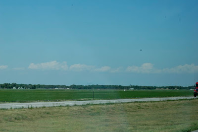
- 5:23 PM CDT – Heading E on 92 towards a scattered cu. field. Beautiful country out here; a little hilly and lots of green. Cows (moo) and horses! So cool.
Final Thoughts
- Chasing is a blast.
- It’s so flat!
- Damn, daylight is really long here.
- I can’t wait to see a storm; hope tomorrow is as good as it sounds.
- Mooooooo!
Photos
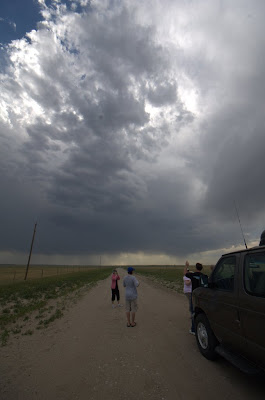
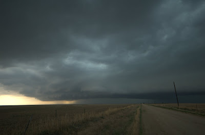
2:20 PM MDT – Observing a boundary early in the afternoon
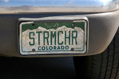
4:15 PM CDT – Took a pic of the license plate at our North Platte break; you should see the expressions some drivers give us when they pass on the highway
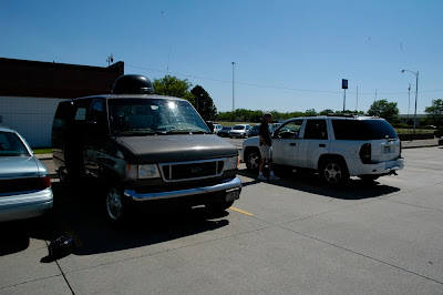
4:16 PM CDT – Taking a break at North Platte

5:37 PM CDT – Watching some cumulus get ripped apart at Merna, NE
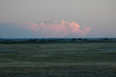
9:30 PM CDT – Observing a storm way off in the distance; yes, it is still light out at this time! Crazy.
June 19, 2006 – Day 2 Summary - The Hitchhiker's Guide to Nebraska
Summary
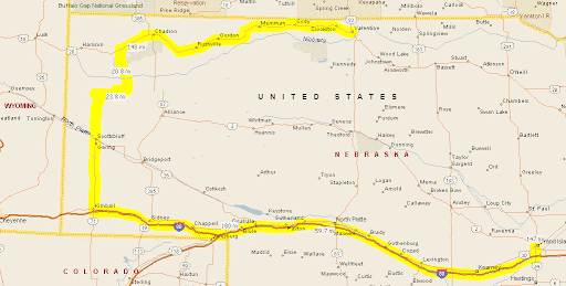
- Route map
- Photo Gallery
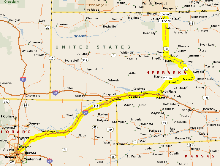
- Trip meter: 576 miles
- From: Valentine, NE to Grand Island, NE
- Summary: Observed a small, struggling, high-based storm; ate at Arby’s
Realtime Updates
8 AM – Good Morning, Tornado Alley!
Morning everybody. Another day, another change of plans. We were originally going to leave at 8 for Montana, but now we’re chilling until 10 and we’re just going a little further west into northeastern Wyoming. Luckily our new target is quite a bit closer; today was looking to be a really long day. It looks like there is a good potential for some nice rotating supercells, maybe even a tornado. (I did it! I said the T-word!)
11 AM – Wooo
We just had a little learning session with Roger in his hotel room on supercells and how they form. He has some awesome photos of all types of storms and tornadoes as examples.
The setup for today is quite a bit better than yesterday. We are targeting east-central Wyoming, where there is good shear, decent mid-level wind speed, and a moderate amount of moisture. Dewpoints in northwestern Nebraska are already in the mid-50s, and the easterly wind combined with an upslope flow of the surface winds should fire off some storms by mid afternoon. These will likely be high-based, but hopefully will move into the better, more moist air to the east, where we can follow them back towards tomorrow’s target of Iowa. Tomorrow’s going to be the big day, but I’m hoping today will not be too shabby, either.
Long summary
Today’s forecast was marginally better than yesterday’s, yet still no better than marginal. We moved our target much closer from Montana to eastern Wyoming, so we had plenty of time to kill in the morning. We had a teaching session in Roger’s Hotel Room for an hour before leaving, and then we cruised west on Route 20 to Chadron, where we took a break in Chadron to have lunch, go to Wal-Mart, and to assess the situation. Alex had the bright idea of playing everybody’s favorite one-hit wonder,Lou Bega’s “Mambo No. 5,” on the jukebox at the Pizza Hut. Boy did we leave there in a hurry.
The biggest limiting factor today, as forecast, was the amount of moisture available. Alex and I tried hopeleslly to play frisbee or football in the Wal-Mart parking lot, but it was impossible because of the steady wind screaming out of the southeast. We were hoping that this wind would bring up moisture from the gulf, but dewpoints in the region failed to rise above the low 50s.
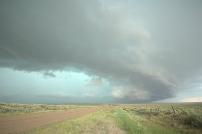
On radar, we watched a huge storm go bonkers in northeast Colorado and then decided to cruise south into more moist air. We intercepted a little storm in Sioux county, just off Route 71, and watched it for a while. The first advice I received upon stepping out of the van? “Watch for snakes.” The storm was multicellular with two updraft bases, but everything was poorly defined and fuzzy, and it showed no sign of intensifying.
Roger was going nuts about a storm just moving into southwest Nebraska, about an hour south of our location. He was concerned because he didn’t want to get so far from our hotel reservations way up in northeast Nebraska, but we were finally able to get cellphone reception, he cancelled our rooms, and we shot south into Kimball county. Of course, by the time we arrived, the once lightning-intensive storm had gusted out and had turned to crap. Blast.
We had dinner in Sidney, claiming itself as “One of America’s favorite stopping places since 1867” in brochures, and witnessed some awesome mammatus out of the dying supercell. I talked with a truck driver who was en route from Seattle to Memphis, and he told me, as you have probably guessed, about his UFO encounter out in Nevada.
Meeting time is 8 AM tomorrow; we’ll see what happens.
Final Thoughts
- I apologize for the poor picture quality; I will post-process these pictures when I return.
- I may not be a severe storms researcher, but I did stay at a Holiday Inn Express last night.
- I am reeeeeally excited about tomorrow! You out in Readerland should be, too!
- “Mambo No. 5” is still stuck in my head.
Audio
- 3:52 PM –
- 5:39 PM –
- 7:50 PM –
- 8:55 PM –
- 10:09 PM –
Photos
4:52 PM – This is the first little storm that we stopped to observe. We saw a few lightning strikes and heard some thunder, but that was all. Nobody around for miles.
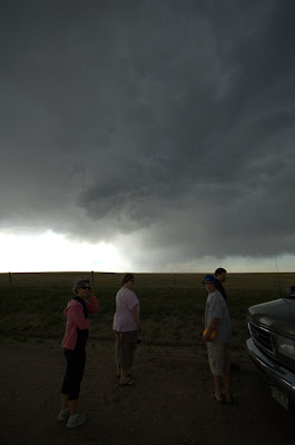
5:24 PM – As the storm propigated over us, it tried desparately to develop a new updraft base, but failed. We left right after this picture.
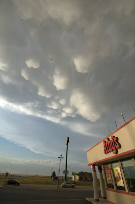
7:36 PM – Arby’s and mammatus clouds: it just doesn’t get any better.
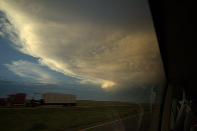
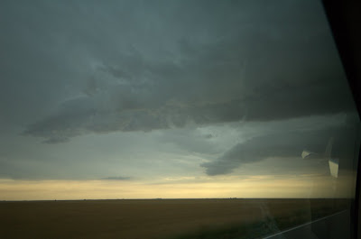
8:17 PM – Looking out the window on the way back. I wish we could have stopped to photograph that for real; it was just beautiful.
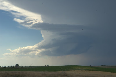
June 20, 2006 – Day 3 Summary - Success!

Summary
- Route map
- Photo Gallery
- Trip meter: Far
- From: Grand Island, NE to Ogallala, NE (actual name)
- Summary: Witnessed two long-lived supercells, one LP and one classic; saw a killer lightning show
Excessively Long Summary
Words alone can’t describe how unbelievable today was. Months of reading, learning and discussing all came together in this chase. Today was all about making the right decisions. We travelled 90 miles east of Grand Island just so we could sit at another Wal-Mart and make a decision of whether to go east into Iowa or back west to Colorado. Iowa had insane sheer but also an insane cap, whereas northeast Colorado had upslope flow and good moisture going for it, but nonexistant directional sheer.
Roger decided that the COlorado setup looked better, so we retraced our steps from that morning. By the time we were around North Platte, storms were already firing off the Cheyene Ridge and were intensifying as they moved westward. The first few cells went up in a cluster, but one storm quickly dominated. It did a hard right-split, as expected, but unexpectedly the right storm quickly shrivelled up and the left storm took precedence. We followed this cluster of storms north from the I-80/I-76 split.
Way off to the south, we could see rock-hard updraft towers of storms in northeast Colorado, 100 miles away. Roger then made the hardest decision of the day to retrace our steps back south to catch up with those storms. It turned out to be the right decision.
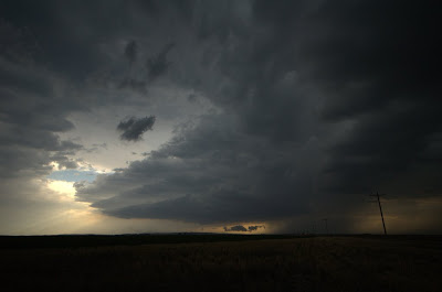
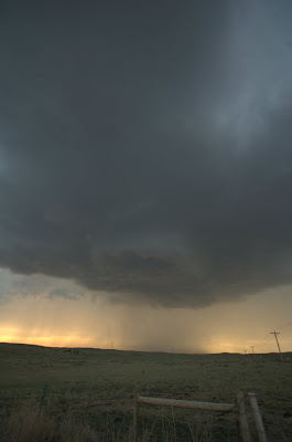
We sped south and approached the biggest storm from the north, which soon became tornado-warned from a “trained spotter sighting,” but this was likely a false alarm. Either way, the storm was intensely rotating on radar, with over 160 knot gate-to-gate shear. We drove through the leading edge of its precipitation core and observed two massive inflow bands streaming into the storm. We stopped south of the storm to see its structure. It was a textbook LP storm, with a very high base and a corkscrewing updraft tower, with striations all along the base. It was truly amazing.
Over an hour or so, the storm slowly propigated directly over our heads, creating lowering after lowering, just trying to spin something up. A huge RFD cut form and occluded part of the meso, and there may have been a tiny funnel back in there, but the occlusion disconnected from the storm and promptly died. After that the storm basically quit, but it tried for the longest time to stay alive and fooled us a few times even as it was gusting out.
We moved slightly further south to watch another, much larger, supercell approach us. This one had classic structure with a nice round base that was relatively low to the ground, and it had strong, strong rotation. Scud was being sucked up into the base, and a wall cloud formed, but the storm gradually gusted out.
As if those displays of nature’s power weren’t enough, soon the sun sank behind the supercell and lit up the whole underside of the storm, with lightning to complement it. What a show. The pictures tell the whole story.
Well, the pictures tell most of the story. To know what it feels like to stand in the path of a storm twenty miles across and twelve miles high, you really have to just go do it. Read all the textbooks, watch Twister a dozen times, or look at the pictures over and over; they are all static. Nothing can truly express the dynamic nature of these beasts, short of being there to witness – no, experience – it.
What a trip.
Quotes of the Day
Roger: (as we turn around) “I can’t do it. I can’t chase this thing. It’s crap.”
Steve: “You’ve got to watch out, Roger; you wouldn’t want any hail to dent the van.”
Final Thoughts
- Everyone agrees that today was absolutely worth the two days of frustration. You would, too.
- Iowa didn’t see crap today! Phhhbbbbtttttt :-P (and I even wore my Iowa shirt!)
- I’m beginning to see the advantages of chasing outside of a chase tour, namely not having to climb out of the back of the van whenever we stop.
Audio
- 9:40 AM –
- 12:42 PM –
- 3:52 PM –
- 6:33 PM –
- 7:26 PM –
- 8:03 PM –
- 10:38 PM –
Photos
Check out those two inflow bands! Craziness.
Finally on the south side of the storm. Check out the stacked-plate base. Insane.
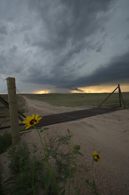
Getting a little artistic as the storm drops some suspicious lowerings.
The storm is much closer now; check out that awesome lowering out of the base.
What lighting!

Shot of the day, right there. This was the last shot I took before the rain came and we had to pack up.
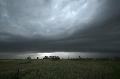
June 21, 2006 – Day 4 Summary - More Frustration
Summary
- Photo Gallery
- Trip meter: Beats me
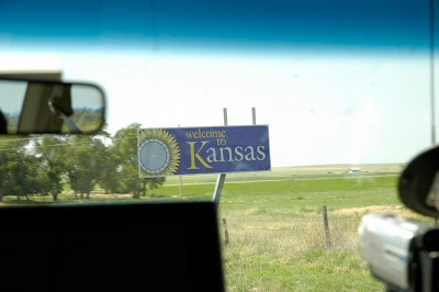
- From: Ogallala, NE to Great Bend, KS
- Summary: Intercepted a squall line; watched a nice lightning show after dark
Realtime Updates
11 AM – Goooood morning
Good morning from the wonderfully-named Ogallala, NE (yes, we’re still in NE). The Dodd City, Kansas balloon sounding is a textbook “loaded gun” sounding. I love it. We are headed to Colby, KS (!) to assess the situation, and then either head west or east depending on which setup Roger likes better.
Shorter-Than-Usual Long Summary
I’m exhausted, so this is going to be quick. There were three major plays for today: north-central Nebraska, central Nebraska, and northeastern Colorado. Nebraska had tons of instability (3000+ J/kg of CAPE) and moisture, and a little bit of shear. Colorado had upslope flow going for it, and lots of shear, but not so much moisture and a massive cap.
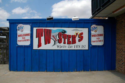
We went south and then west to lunch at Twister’s Bar and Grill in Colby, Kansas (“Just across from the big blue water tower!”) and make a choice. We finally decided to blast east to meet up with the boundary spreading across the center of the state. In fact, conditions were so good in this area that the cap broke all at once and all the good-looking storms quickly formed a linear, outflow-dominant system. Blast.
We drove south through the line of storms and ended up on the south side, and stopped briefly to watch an embedded meso with a massive wall cloud propigate over our heads. It didn’t last long, and we then went back north up to Great Bend to get our hotel.
Roger and I, instead of going for dinner at Perkin’s, grabbed McDonald’s and drove east a few miles outside of town in order to get some lightning video and stills. We got some good ones of lightning striking a radio tower (see below).
Of course, back in northeast Colorado, many individual supercells formed three hours after we left. They quickly became tornado-warned for the rest of their lives. Despite this, there was only one confirmed tornado report from an NWS employee, and it was likely a landspout-type tornado.
Final Thoughts
- Note to self: try not to get camera gear so wet next time; condensation inside the lens is no fun.
- Chasing is such a learning experience; I learn new strategies each day. I love it.
- 2006 strikes again. Blah.
Audio
- 4:03 PM –
- 8:08 PM –
Photos
Whoa.
Probably the only twister we’ll see this week.

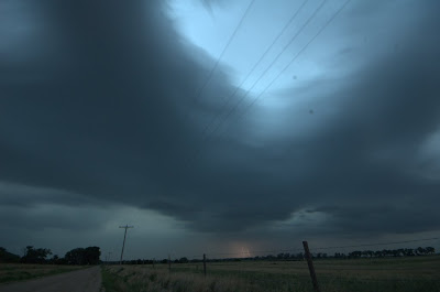
This was the scene in the early afternoon as we approached the boundary from the west. Too bad there was too much of this around.
This was one supercell we caught up with underneath all of that linear crap. It had an ominous wall cloud for a while, but then it quickly dissipated. Blah.
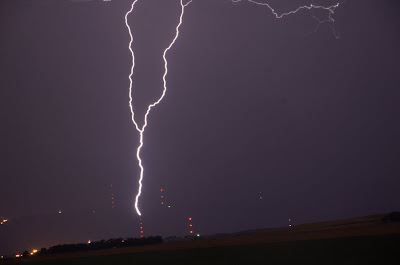
This is ground-to-cloud lightning forking up from a radio tower. I got a handful of shots like this.
June 22, 2006 – Day 5 Summary
Summary
- Photo Gallery
- Trip meter: 603 mi
- From: Great Bend, KS to Lamar, CO
- Summary: Got on several tornado-warned storms; was chased by an HP beast; core-punched a little bit
Long Summary
Today was another frustrating chase day of 2006, but we did as well as we could have done, given the situation. We did not miss anything major, since most of the “tornado” reports today were likely false. From everything we saw, the conditions were not in place at all for the formation of tornadoes. That being said, we did get to see some awesome gust-front action.
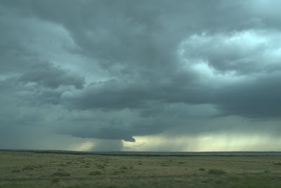
We went west from Great Bend along I-70 and into Liman, Colorado. I forget exactly what happened here. I know we passed through Liman several times after that, traveling north to catch some cells that quickly died, and then we went back south on some tornado-warned cells that quickly gusted out and went linear.
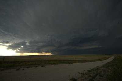
That was when the fun began. We ended up on the leading edge of a massive gust front. We stopped to photograph it for a bit, but as the hail core came up over the next hill, Roger yelled “We gotta go! We gotta’ go now!” and oh how we went. We blasted ahead of the massive high-precipitation beast of a storm that was bright green in its center. That’s an indicator of large hail; Roger was very eager to stay in front of it after all the hail damage the van received last week. This thing was massive, and was bearing down on us quickly. Looking behind the van, the shelf cloud looked like a the mouth of a giant monster ready to eat the van.
Out in front of this storm, the winds were gusting in a straight line almost at the speed of the van. Those were straight-line winds of fifty, maybe even sixty or seventy miles per hour! We were racing along with the wind to our back, and blowing dust decreased the visibility to zero at some points. We also saw many, many gustnadoes. Cows, too.
We went further south, out of the path of all that garbage, to intercept another line of garbage. An embedded meso in the line gave the storm a tornado warning, with first indications being the tornado was spotted on the ground. We core-punched that storm through heavy rain, wind, and some hail, and drove right underneath the rotating mesocyclone. Short of being on a roller coaster, I didn’t previously think there was any other way to get such an adrenaline rush while sitting down.
Eventually the tornado warning was dropped. We went south and then east through a squall line twice, but turned around the second time when all chances for a tornado had gone to zero (not that there was any chance to begin with).
For all the crappy storms out there today, I think we did quite well. The pictures definitely confirm that.
Final Thoughts
- “What a beast!”
Audio
- 12:01 PM –
- 3:06 PM –
- 3:42 PM –
- 3:58 PM –
- 5:03 PM –
Photos
This is a suspicious lowering we spotted in a storm early on.
This is the first good view we got of this massive storm. It has already taken on a shelf cloud and a gusted-out appearance.
Soon it started bearing down on us. Notice all the bluish-green under that thing? Hail, hail, and more hail.
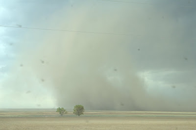
This is a huge gustnado that kicked up tons of dust when it died.
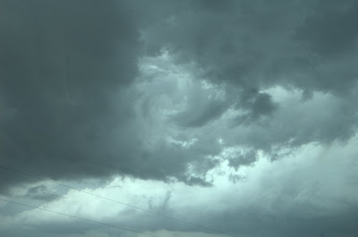
There was all kinds of vorticity along the gust front. The movement in the clouds here was tremendous, but it was nothing dangerous.
Here’s one more look at this monster. Amazing structure.
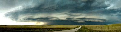
June 23, 2006 – Day 6 Summary - The Grand Finale
Summary
- Photo Gallery
- Trip meter: Your guess is as good as mine
- From: Lamar, CO to Denver, CO
- Summary: Had fun with two LP storms; stared down the gullet of another HP beast
Long Summary
What a great day for a chase tour finale. We travelled straight north out of Lamar for the entire day, meeting up with a beautiful, extremely high-based LP storm around 5:30 just north of Scottsbluff. Like every other LP storm we encountered, it ran into dry air and promptly shrivelled up.
We went further north again and intercepted another ridiculously high-based storm just suspended in the air. As we watched from the southeast it developed a very strong RFD cut that nearly killed the storm, but it slowly rebuilt its base. As we travelled north yet again, it became apparent why; looking back on the storm from the northeast, rock-hard updraft towers were boiling up into the atmosphere. It looked rather ridiculous, with these massive updraft towers so high off the ground just slamming into the jet stream and racing westward. That thing didn’t quit sucking air for another couple of hours.
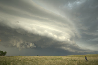
As you probably guessed, we again travelled north to meet up with a supercell screaming southwest towards us. We had watched this storm develop on radar over the past hour or two, thinking it out of reach, but it was trucking southward and by the time we reached it, it had developed a massive shelf cloud and was gusting like nobody’s business. It was definitely supercellular, with the rain core wrapping fully around the rapidly rotating meso, totally obscuring any chance of possibly seeing a tornado, had it been able to produce one. This storm then gusted out and proceded to race with us back southward.
The motion along the leading edge of this storm was unlike anything I’ve ever seen. The gust front was churning and scouring the atmosphere. Little rotating eddies created all kinds of rotating clouds. Standing a few miles in front of the beast, you would feel a warm southeast wind at your back being sucked up into the storm. Then it would be calm, as the storm approaches and the air is literally rising straight up into the monster. Then the cold outflow wind hits your face and kicks up dust. That’s your cue to get out of the way.
What an experience. We’re on the way back to Denver tonight, and I fly home tomorrow. Thanks to Roger, Dave, Steve, and everyone at Silver Lining Tours for an amazing week. Given the conditions and 2006’s dreadful reputation, I could not have asked for anything more. The best of luck to everyone in the high plains tour next week; it looks like a Death Ridge is approaching that might send you packing to Canada looking for storms.
Final Thoughts
- Final tally: we saw 10 Wal-Marts and 18 Pizza Huts (all data are considered preliminary).
- I don’t want to go home!
- I think I may puke if I have to ever eat fast food again.
- Watch for a “Best Of” post with all the best photos post-processed for your enjoyment.
- Time to start getting ready for the 2007 chase season.
Audio
- 4:42 PM –
Photos
Say hello to LP #1; look at the rapid rotation

I just love this
LP #2 from the north side
The midlevel winds really sculpted this shelf cloud on the HP storm
Actual size
Stitched panorama of the HP supercell